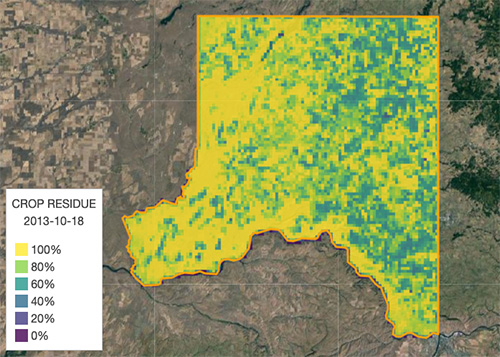
Estimating Crop Residue Cover in Whitman County
About
The Palouse Conservation District has been working with researchers at the University of Idaho to estimate changes in crop residue in Whitman County. The goals for this project are to:
- Measure crop residue in 90 fields including a variety of conventional tillage, mulch tillage, and no-till management practices
- Track and map changes in crop residue from 2013 to present, as data become available, in all the sub watersheds (HUC 12) found in Whitman County
The field measurements along with freely available moderate resolution satellites are used to develop a statistical model that estimates fall crop residue cover. Palouse Conservation District staff will continue to collect field measurements over the next several years to further refine the estimates of fall residue cover. This work has been funded by Washington State Department of Ecology.
Crop Residue Cover Data Viewer
Map a vegetation indicator and compute summary statistics over regions within Whitman county.
Team
The team working on this project is Palouse Conservation District staff and University of Idaho faculty and staff.
Please contact us with any questions or Ideas.


Vincent Jansen
Remote Sensing and GIS AnalystWashington Department of Fish and Wildlife
(formerly University of Idaho Post Doc)
Jennifer Hinds
Research Applications ArchitectResearch Computing and Data Services, University of Idaho
Contact
Location:
1615 NE Eastgate Blvd. Suite H, Pullman, WA 99163
Email:
PalouseCD@PalouseCD.org
Call:
509-332-4101