About the Model
This application contains fall Residual Crop Residue Cover (RCRC) estimates for Whitman County, Washington. RCRC is estimated from remote sensing data.
The PalouseSAT's Residual Crop Residue Cover product provides percent cover estimates from 2013 to present (as data become available) for clear Landsat 8 scenes between September 1 and November 30.
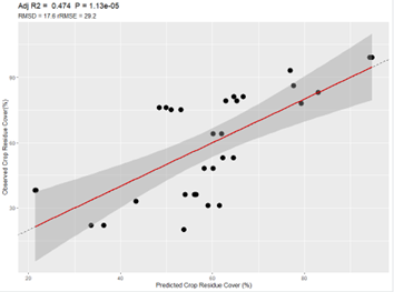
The estimates were produced fitting a three parameter linear model to field data collected across Whitman County in 2021. The modeling used methods described by Jansen et al. 2018.
Several models were compared and the selected model balanced accuracy with complexity using normalized difference tillage index (NDTI), the near-infrared (NIR) band and the shortwave infrared 2 (SWIR2) band. Using the full 2021 dataset we an r2 of 0.47 and a relative RMSE of 29.2%. This model be continually improved as new data is collected.
REFERENCE:
Jansen, Vincent S., Crystal A. Kolden, and Heidi J. Schmalz. 2018. "The Development of Near Real-Time Biomass and Cover Estimates for Adaptive Rangeland Management Using Landsat 7 and Landsat 8 Surface Reflectance Products" Remote Sensing 10, no. 7: 1057. https://doi.org/10.3390/rs10071057